
@olaf28
He says it was his first mapping project and have now learned, but I also got wondering.
There's too many people that all of a sudden just abandon a project!
[REL] Caribbean Map for ATS 1.1 by TerraMaps
Re: [WIP] Caribbean Map for ATS
---------------------------------------------------------------------------------------------------------------------------------------------
System: Windows 8.1
Processor: Intel Core i7-4790@
Memory: 16GB
Graphics: ASUS GeForce GTX1660Ti

System: Windows 8.1
Processor: Intel Core i7-4790@
Memory: 16GB
Graphics: ASUS GeForce GTX1660Ti

Re: [WIP] Caribbean Map for ATS
@Begnan,
Yes that's what I read also, but the new parts for version 5.0 looked very promising. There where video's and he was near beta testing. And then he droped the whole project.
Of course I can understand that making een fresh start helps. But I am now careful to immediately look for cooperation with Duckie. First see what Hawaii delivers.
But that's my 2 cents
Proc: i7-9750H 2,6 GHz (max. 4,5 GHz)
Mem: 16GB
Graphics: ASUS ROG -STRIX-RTX2060-O6G-GAMING 6 GB GDDR6
Mem: 16GB
Graphics: ASUS ROG -STRIX-RTX2060-O6G-GAMING 6 GB GDDR6
Re: [WIP] Caribbean Map for ATS
@olaf28
Then you must have stolen my two ones!
Then you must have stolen my two ones!
---------------------------------------------------------------------------------------------------------------------------------------------
System: Windows 8.1
Processor: Intel Core i7-4790@
Memory: 16GB
Graphics: ASUS GeForce GTX1660Ti
System: Windows 8.1
Processor: Intel Core i7-4790@
Memory: 16GB
Graphics: ASUS GeForce GTX1660Ti
Re: [WIP] Caribbean Map for ATS
Oh but then my assets have doubled this month 

Proc: i7-9750H 2,6 GHz (max. 4,5 GHz)
Mem: 16GB
Graphics: ASUS ROG -STRIX-RTX2060-O6G-GAMING 6 GB GDDR6
Mem: 16GB
Graphics: ASUS ROG -STRIX-RTX2060-O6G-GAMING 6 GB GDDR6
Re: [WIP] Caribbean Map for ATS
@olaf28
Then be careful with all those resources!
Then be careful with all those resources!
---------------------------------------------------------------------------------------------------------------------------------------------
System: Windows 8.1
Processor: Intel Core i7-4790@
Memory: 16GB
Graphics: ASUS GeForce GTX1660Ti
System: Windows 8.1
Processor: Intel Core i7-4790@
Memory: 16GB
Graphics: ASUS GeForce GTX1660Ti
Re: [WIP] Caribbean Map for ATS
The curse of being in in Eastern Time is you wake up to 16 replies. :)
I am fully aware of another mapper trying to claim Cuba on ATS. In fact, this is what caused me to rush an early announcement of my side project. I started working casually on Bahamas back in the Spring time to test out some defs to utilize in my Red Sea Map project (as ATS runs a lot quicker for some reason on my PC than ETS2). I had Bahamas created for a long time, and since the flags were similar to Sudan which I'm building in Red Sea, I was able to really experiment with new tasks I was learning at that time so now it got to the point where after enjoying a drive in the aqua blue water on the map with a Bahamasair trailer, I had to share this with the world. I also developed a personal plane to balance both map projects, NONE of them will be abandoned I can guarantee that.
On a second major point, my map projects are a TEAM effort, I do not map alone. I am convinced that in order to create a great project, you need a strong team of detailed beta testers who will test it in depth before a public release, a research department made of those who specialize in that geographic area who can assist with making it look realistic and help create the illusion of the driver that they are really there, and then a support team (Olaf in my map projects' case) who can assist the community and coordinate accordingly. Also, I have a second developer and may even bring on a third.
Finally, I don't see any indication of the other Cuba project utilizing C2C, so I'm not sure how he plans to connect to the rest of the United States. I already have modified the closed road on C2C's Fort Lauderdale port area, which like IRL there is a ferry port east of the airport (that even has ferries to the islands as well!).
Regardless of what the future holds with our maps, I am definitely making Guantanamo Bay as I have real life experience visiting that area. The rest of Cuba, I foresee two options:
1. We coordinate and can meet halfway somewhere
2. We make our own separate projects and the community can choose which one they want to download. (Just like how you can choose EURoadNet or ProMods, and soon Canadream or ProMods Canada, etc.)
Re: [WIP] Caribbean Map for ATS
@b738pilot
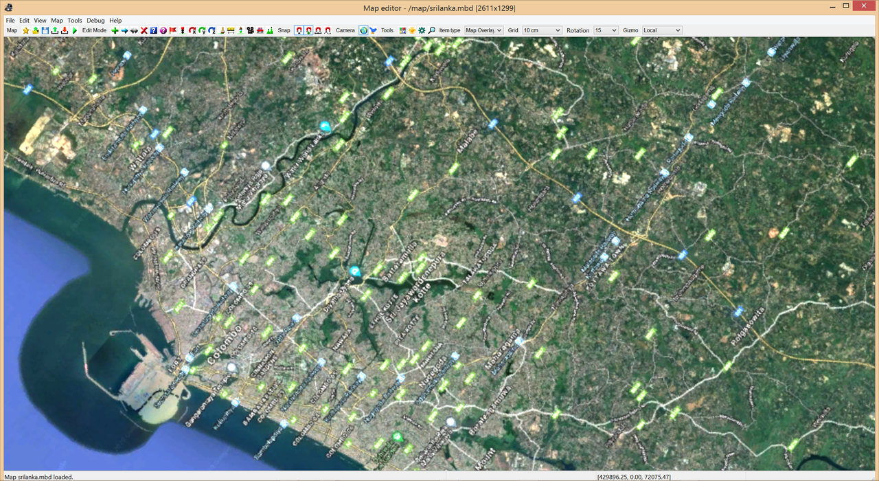
Thanks for the info and nicely spoken! I can tell you that I'm now finished
registering the Sri Lanka Map Editor BG and it looks like this in game when
correctly positioned. I use three significant points to register and in the
following image you can see the in-game road numbers at those points.

And here it shows how Colombo city looks like in the Editor.
Question! In your upcoming ME BG, are you really going to map anything
on those eastern islands like Guadeloupé, Dominica, Martinique, Barbados
and Grenada e.g.? They don't seem to be big enough for a scale of 1:19?
Can I exclude them?
Thanks for the info and nicely spoken! I can tell you that I'm now finished
registering the Sri Lanka Map Editor BG and it looks like this in game when
correctly positioned. I use three significant points to register and in the
following image you can see the in-game road numbers at those points.
And here it shows how Colombo city looks like in the Editor.
Question! In your upcoming ME BG, are you really going to map anything
on those eastern islands like Guadeloupé, Dominica, Martinique, Barbados
and Grenada e.g.? They don't seem to be big enough for a scale of 1:19?
Can I exclude them?
---------------------------------------------------------------------------------------------------------------------------------------------
System: Windows 8.1
Processor: Intel Core i7-4790@
Memory: 16GB
Graphics: ASUS GeForce GTX1660Ti
System: Windows 8.1
Processor: Intel Core i7-4790@
Memory: 16GB
Graphics: ASUS GeForce GTX1660Ti
Re: [WIP] Caribbean Map for ATS
Nice, as I stated earlier, your work is very impressive and helpful to the community!
If I do those islands in the east, it won't be for a while. Plenty to be done in the West Indies like Bahamas, Cuba, Haiti, Jamaica, etc. But I plan on the Caymans even though it'll be like one or two roads with one job site, probably at the airport.
If I do those islands in the east, it won't be for a while. Plenty to be done in the West Indies like Bahamas, Cuba, Haiti, Jamaica, etc. But I plan on the Caymans even though it'll be like one or two roads with one job site, probably at the airport.
Re: [WIP] Caribbean Map for ATS
@b738pilot
Okay, I'll see what I can do! I'm going to start with this project now then!
I'll keep you informed! You have requested the OpenStreetMap kind of BG,
so that's what you gonna get!
EDIT: I think we should take this area in a first step and make another BG
if and when you will get to the eastern most islands! The original image
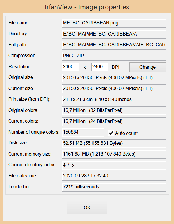
that was fetched from OpenStreetMap has a resolution of 20150x20150.
What you see here is just screenshot of that full image.
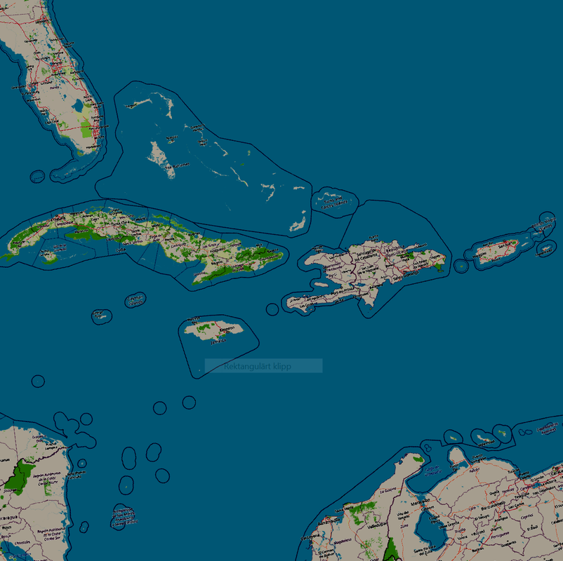
Some interesting info about the original image.
Okay, I'll see what I can do! I'm going to start with this project now then!
I'll keep you informed! You have requested the OpenStreetMap kind of BG,
so that's what you gonna get!
EDIT: I think we should take this area in a first step and make another BG
if and when you will get to the eastern most islands! The original image
that was fetched from OpenStreetMap has a resolution of 20150x20150.
What you see here is just screenshot of that full image.
Some interesting info about the original image.
---------------------------------------------------------------------------------------------------------------------------------------------
System: Windows 8.1
Processor: Intel Core i7-4790@
Memory: 16GB
Graphics: ASUS GeForce GTX1660Ti
System: Windows 8.1
Processor: Intel Core i7-4790@
Memory: 16GB
Graphics: ASUS GeForce GTX1660Ti
Re: [WIP] Caribbean Map for ATS
That's beautiful! Yeah I like it a lot! That'll for sure make it more convenient for me to plot the cities/towns on the islands where they should go